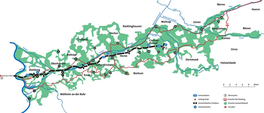
Part of the infrastructure landscape of the Ruhr Metropolitan Area
Parkautobahn A42
 © Manfred Vollmer
 © Hier muss das Copyright redaktionell nachgetragen werden
 © Hier muss das Copyright redaktionell nachgetragen werden
 © Hier muss das Copyright redaktionell nachgetragen werden
At the present time, almost 17,500 hectares of land in the metropolitan Ruhr area are covered with differing infrastructures. Of the total area, 9,250 hectares consist of green areas accompanying the infrastructures. This is equivalent to about 12% of the total area of Emscher Landscape Park. The different infrastructure corridors often run together meaning that the adjacent areas overlap with one another in places, border on one another, or result in ribbon-like residual spaces. In order to push forward the integration of the existing and often mono-functional infrastructures, it is important to be aware of the adjoining utilisations as well as the needs and the development options concomitant with these. And it is also important to understand the logic behind the different individual parties responsible for the various utility infrastructures. A systematic and parallel consideration of these logical standpoints shows that the existing systems could be conceptually developed and in some places could dovetail with one another. Taking this as a basis, five particularly relevant fields of action which could initialise and force the reintegration of existing infrastructure corridors can be defined: inhabitation and appropriation, cultivation and management, orientation, ecological improvement, connecting/linking.
If one understands the surface areas in Emscher Landscape Park determined by the infrastructures as an independent, important element of the park, this opens up new development perspectives for the regional park and the region. By thinking these areas together, access is provided to functional, design, social and ecological options which are no longer only the result of the individual interests of single or random spatial constellations, but rather provide a (landscaped) space in which the aforementioned qualities are cultivated and made accessible to the people in the region as well as tourists. The way to this infrastructure landscape cannot be prescribed from the top down. On the contrary, it requires an intense and sustainable discussion between the people responsible for the infrastructures and those responsible for regional and municipal (spatial) planning.
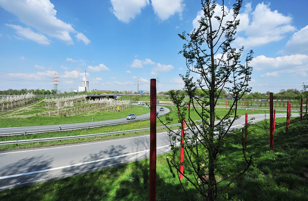
Based on the geographical location of the road in Neues Emschertal, the “Parkautobahn A42” project is developing the A42 German federal motorway as the spine from which the Emscher Landscape Park is accessed. This function is to be further refined and illustrated with the help of different design elements. In the long term, stable existing vegetation should help in this process to come up with a design that will preserve the adjacent areas in a sustainable manner that is simpler and more cost-effective but at the same time upgrades them in ecological terms. Where it makes sense and is possible, the autobahn will be visually linked to the park thus aiding orientation in the area. The importance of the autobahn junctions for the park will be further developed. Work has already started to convert the existing vegetation with the aim of creating greater transparency (visual axes to particular points) and a new “orientation tree” has been introduced; to give the existing noise protection barriers a new design by setting up so-called “ear parks” in the Autobahn intersections; to clearly mark the beginning and end of the park autobahn; to develop the 22 junctions as “park gateways”; and to set up “park petrol stations” at selected junctions as special places creating a link to the Emscher Landscape Park.
This project was presented as part of the 2015 Baukultur Workshops in Regensburg.
| Categories | Infrastructure |
| Region | Nordrhein-Westfalen |
| Developer | Neighbouring municipalities along the A42 motorway – RVR – Emschergenossenschaft / MUNLV / Straßen NRW |
| Planning | |
| Planning partners | Planergruppe GmbH Oberhausen; Ruhr 2010 and Straßen NRW |
| Planning period | 2007-2009 |